Weather Systems and Patterns
Begin
16 pages · ~32 min
Weather Systems and Patterns
This training covers the fundamentals of weather systems and patterns, helping learners understand atmospheric processes and forecast conditions.
What you’ll learn
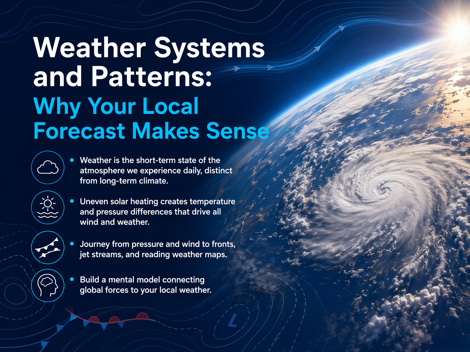
- 01Weather Systems and Patterns: Why Your Local Forecast Makes SenseWelcome. Have you ever looked at a weather forecast and wondered what’s actually driving all those changes? That’s exactly what we’re going to explore together. Think of this as your backstage pass to the sky. We’ll start by understanding that weather is just the short-term mood of the atmosphere—what you feel right now—different from the long-term patterns of climate. All of it, every gust of wind and every storm, begins with the sun heating the Earth unevenly. Those temperature differences create pressure differences, and that sets the air in motion. In this journey, we’ll connect the dots from simple pressure and wind all the way to cold fronts, jet streams, and those weather maps you see every day. The goal is to build a mental model, so when you step outside, you can see the invisible forces shaping your local weather. Let’s start with the engine that makes the wind blow: air pressure and pressure gradients.flexbooks.ck12.orgk12.libretexts.orgces.fau.edu+21 min
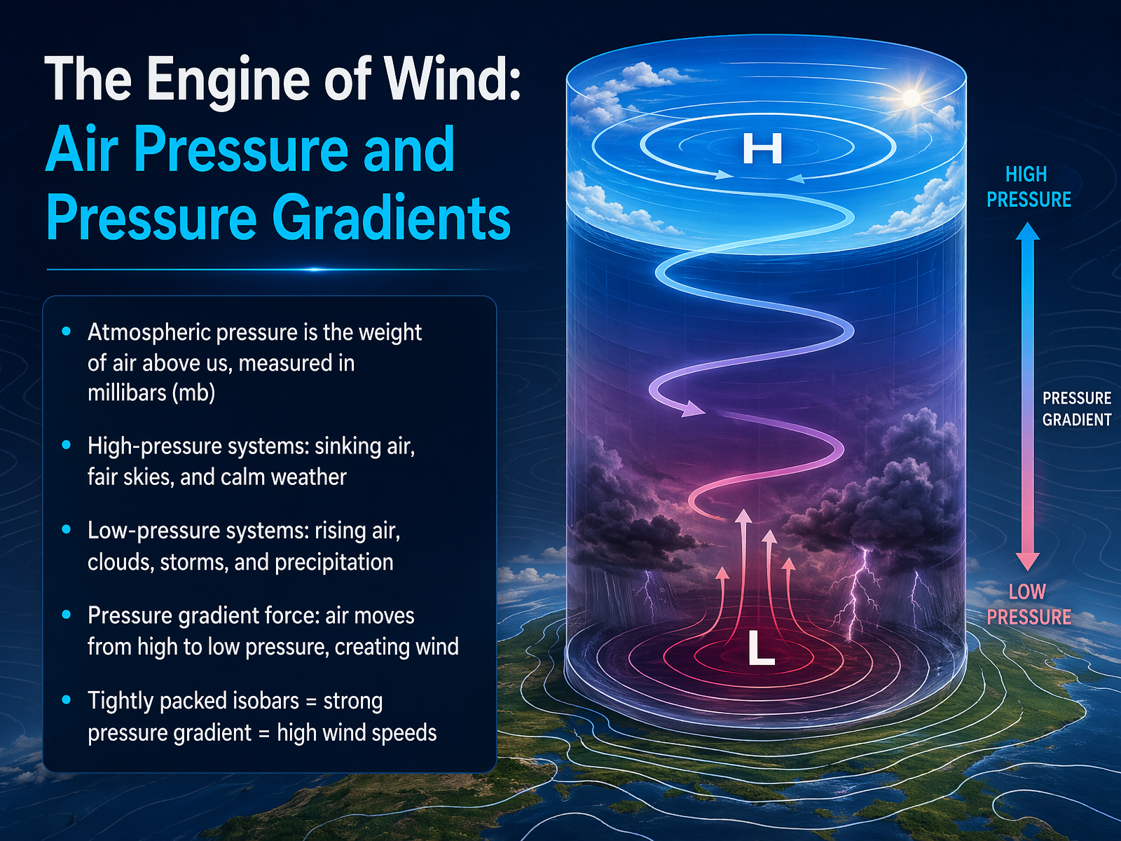
- 02The Engine of Wind: Air Pressure and Pressure GradientsNow let’s look at what actually sets the air in motion. We call it the engine of wind: air pressure and pressure gradients. Think of atmospheric pressure as the weight of all the air stacked above us, pressing down. We measure it in millibars. When you see a big blue H on a weather map, that’s a high-pressure system. Air is sinking there, which discourages clouds from forming, so you typically get fair skies and calm weather. A red L marks a low-pressure system. There, air is rising, cooling, and condensing into clouds, often bringing storms and precipitation. Nature always tries to balance things out. Air moves from areas of high pressure to areas of low pressure. That movement is wind. On a weather map, the lines connecting points of equal pressure are called isobars. When those lines are packed tightly together, it means the pressure changes quickly over a short distance. That’s a strong pressure gradient, and it creates high wind speeds. When the isobars are spaced far apart, the pressure gradient is weak, and the winds are light. Next, we’ll meet the raw ingredients that these winds push around: air masses.
 nesdis.noaa.govgeo.libretexts.orgniwa.co.nz+22 min
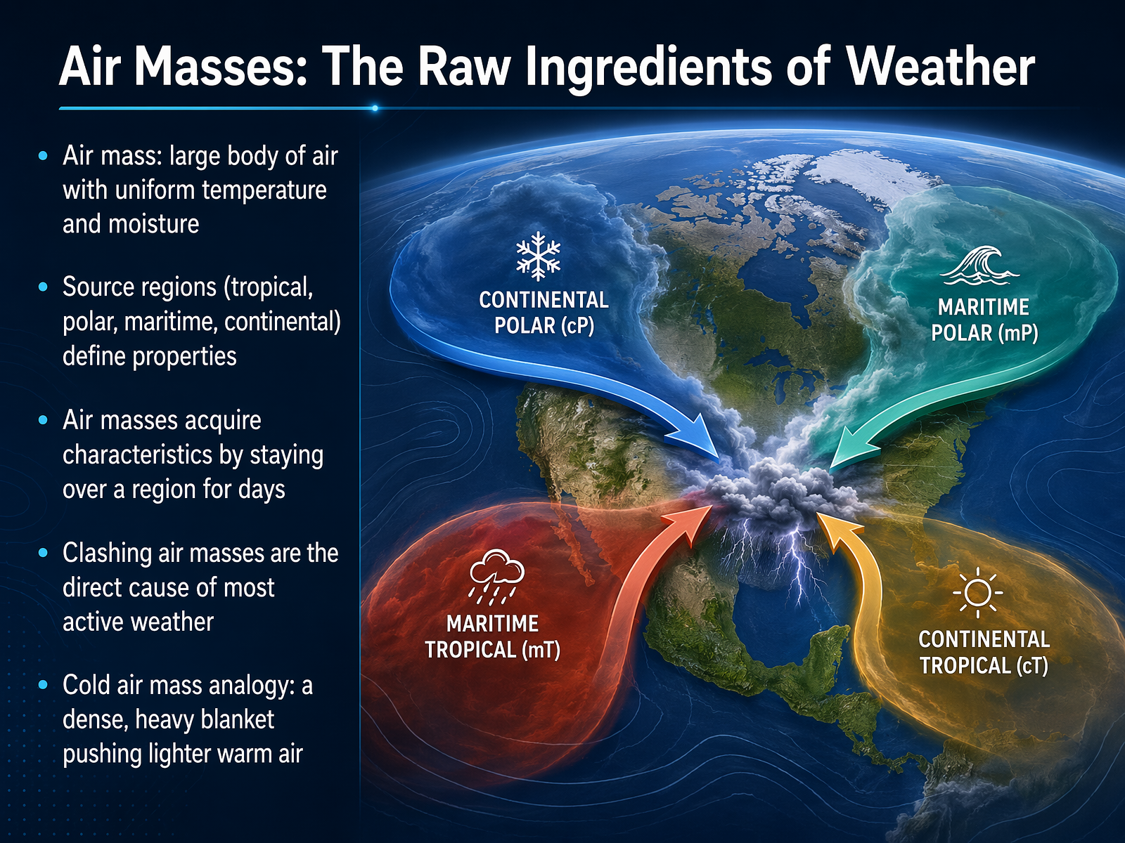
 - 03Air Masses: The Raw Ingredients of WeatherNow, let's talk about the raw ingredients of weather: air masses. Think of an air mass as a huge, invisible blanket of air—sometimes covering thousands of miles—that has a very uniform personality. Every part of it shares roughly the same temperature and the same amount of moisture. Where does it get that personality? From its source region. If an air mass sits for days over a tropical ocean, it becomes warm and wet. If it forms over a cold, icy continent, it's cold and dry. We label these by where they come from: tropical or polar, maritime or continental. The real weather drama starts when one of these massive blankets moves and bumps into another with a completely different character. For example, imagine a cold air mass as a dense, heavy blanket that bulldozes into a lighter, warm blanket, forcing that warm air to shoot straight up. That clash is the direct cause of most of our clouds, rain, and storms. Up next, we'll explore the front lines where these air masses collide—let's look at fronts.
 scied.ucar.eduweather.metoffice.gov.ukokfirst.mesonet.org+22 min
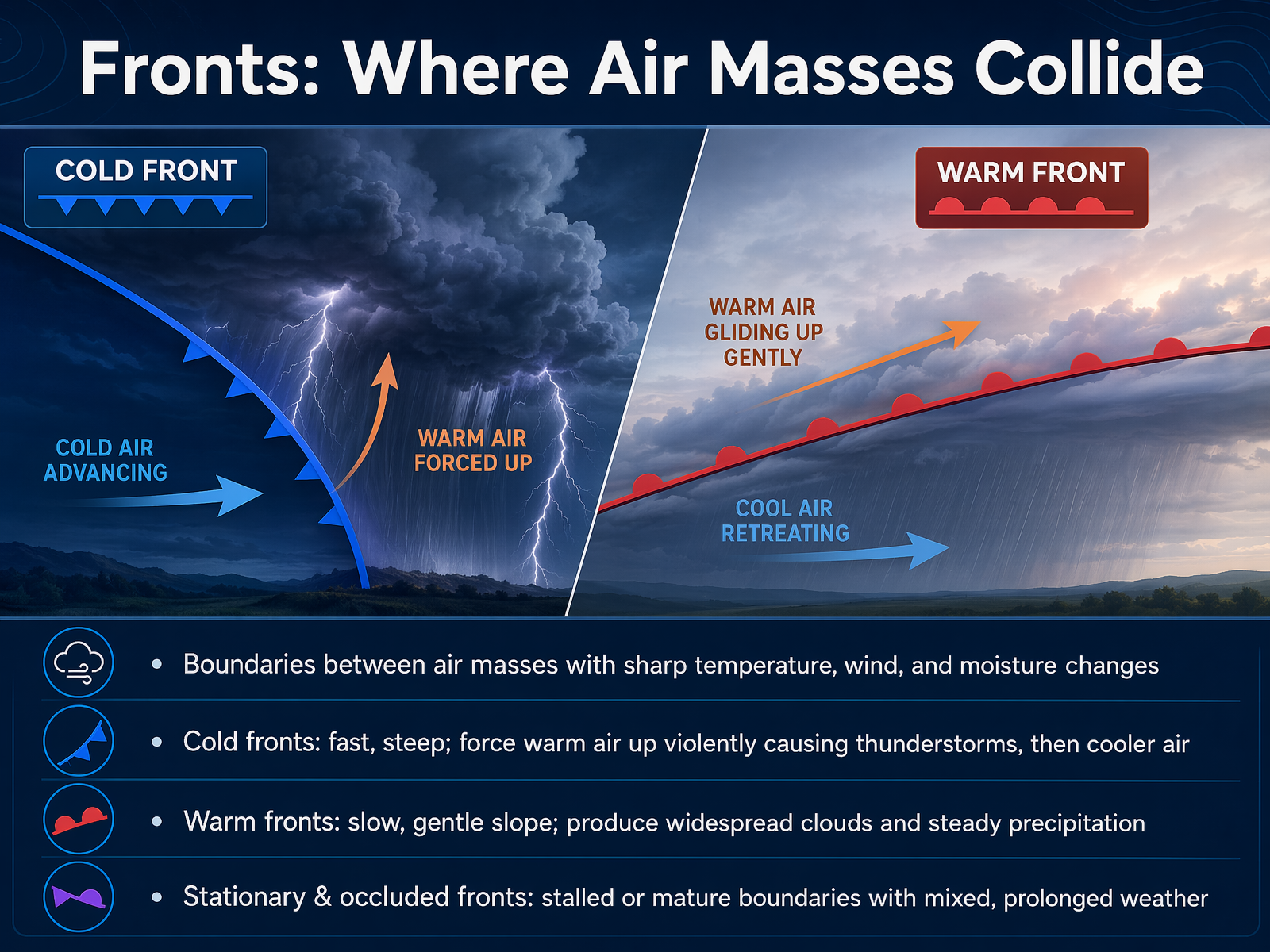
 - 04Fronts: Where Air Masses CollideNow that we've seen how air masses form, let's look at what happens when they meet. The boundaries between these different air masses are called fronts. Think of a front as a clash zone where a warm, humid air mass and a cold, dry air mass collide. This collision creates the weather we experience. There are a few main types, and each one affects your day differently. A cold front is like a fast-moving wedge. Dense cold air slides under warmer air, forcing it to rise rapidly. This sudden lift often creates towering clouds and can trigger dramatic thunderstorms, gusty winds, and a quick drop in temperature. After it passes, you usually get cooler, clearer skies. A warm front is much gentler. Warm air slowly slides up over a retreating mass of cool air. This creates a wide blanket of layered clouds and steady, persistent rain or drizzle that can last for a while. Then there are stationary fronts, which are like a stalled tug-of-war. Neither air mass is strong enough to push the other, so clouds and rain can linger for days. Finally, an occluded front is a more mature stage, where a cold front catches up with a warm front, lifting the warm air completely off the ground. This often brings a mix of weather before the skies eventually clear. Up next, we'll explore the force that gives these systems their spin: The Coriolis Effect, and why winds turn.
 scied.ucar.eduweather.metoffice.gov.ukokfirst.mesonet.org+22 min
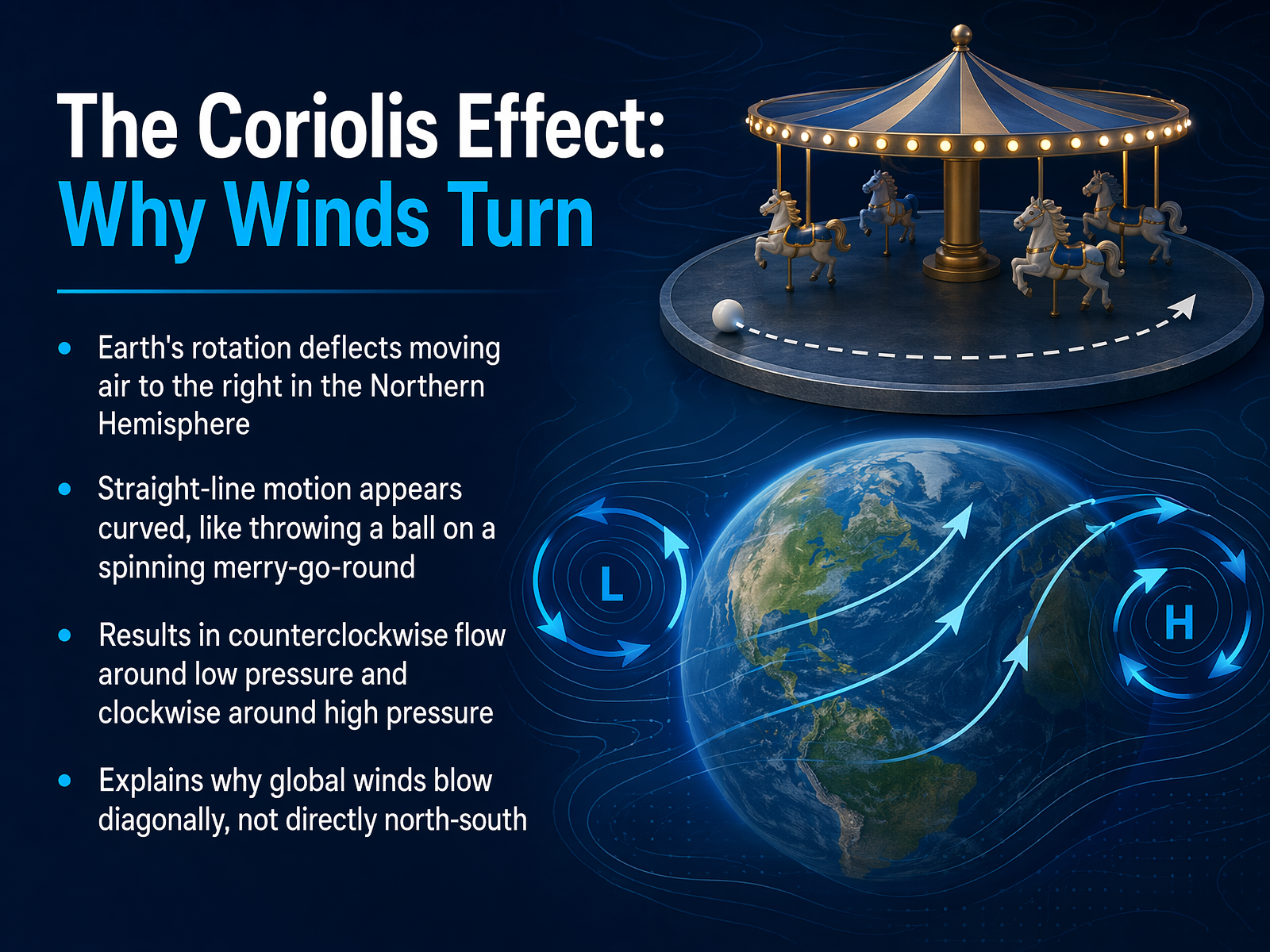
 - 05The Coriolis Effect: Why Winds TurnNow, we have warm air rising and cool air sinking, creating these big pressure differences. But if the Earth wasn't spinning, the wind would just rush in a straight line from high to low pressure, right? Well, our planet does spin, and that changes everything. This is called the Coriolis effect. Imagine you're on a spinning merry-go-round, and you try to throw a ball straight to a friend. The ball doesn't actually go straight; it curves away because your position is constantly turning. The same thing happens with our winds. Because the Earth rotates, any moving air gets deflected. In the Northern Hemisphere, it's always pushed to the right. So, instead of a straight path, winds end up moving on a diagonal. This is why air doesn't just crash directly into the center of a low-pressure system. It spirals inward, creating a counterclockwise flow. And for a high-pressure system, the air spirals outwards, flowing clockwise. That simple curve is the secret to why our weather spins. Let's zoom out and see how this diagonal dance creates the planet's major wind highways.
 flexbooks.ck12.orgk12.libretexts.orgces.fau.edu+22 min
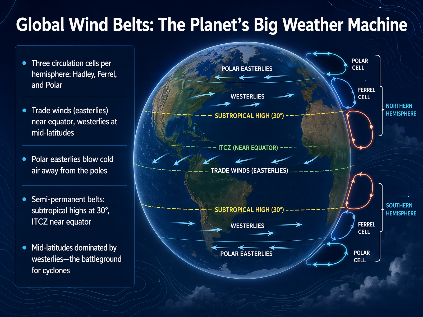
 - 06Global Wind Belts: The Planet's Big Weather MachineNow let’s zoom out and see the bigger picture—the global wind belts that act like the planet’s giant weather machine. Picture Earth wrapped in three huge bands of circulating air in each hemisphere: the Hadley, Ferrel, and Polar cells. Near the equator, intense sunlight heats the air, making it rise and creating a zone of low pressure. As that air sinks around 30 degrees latitude, it builds semi-permanent high-pressure belts—the subtropical highs. Some of that sinking air flows back toward the equator, but the Earth’s rotation turns it, creating the steady trade winds that sailors once relied on. In the mid-latitudes, where we often live, the Ferrel cell drives the westerlies—winds blowing from west to east. This is the battleground where cold polar air and warm tropical air clash, spinning up cyclones and shifting our daily weather. Closer to the poles, the polar easterlies push cold air outward. And near the equator, where the trade winds meet, you’ll find the Intertropical Convergence Zone, or ITCZ, a band of rising air that brings heavy rain and thunderstorms. So these belts aren’t just lines on a map—they’re the engine that moves heat and moisture around the globe. Next, let’s climb higher and explore the jet stream, a river of air that steers our weather systems.
 flexbooks.ck12.orgk12.libretexts.orgces.fau.edu+22 min
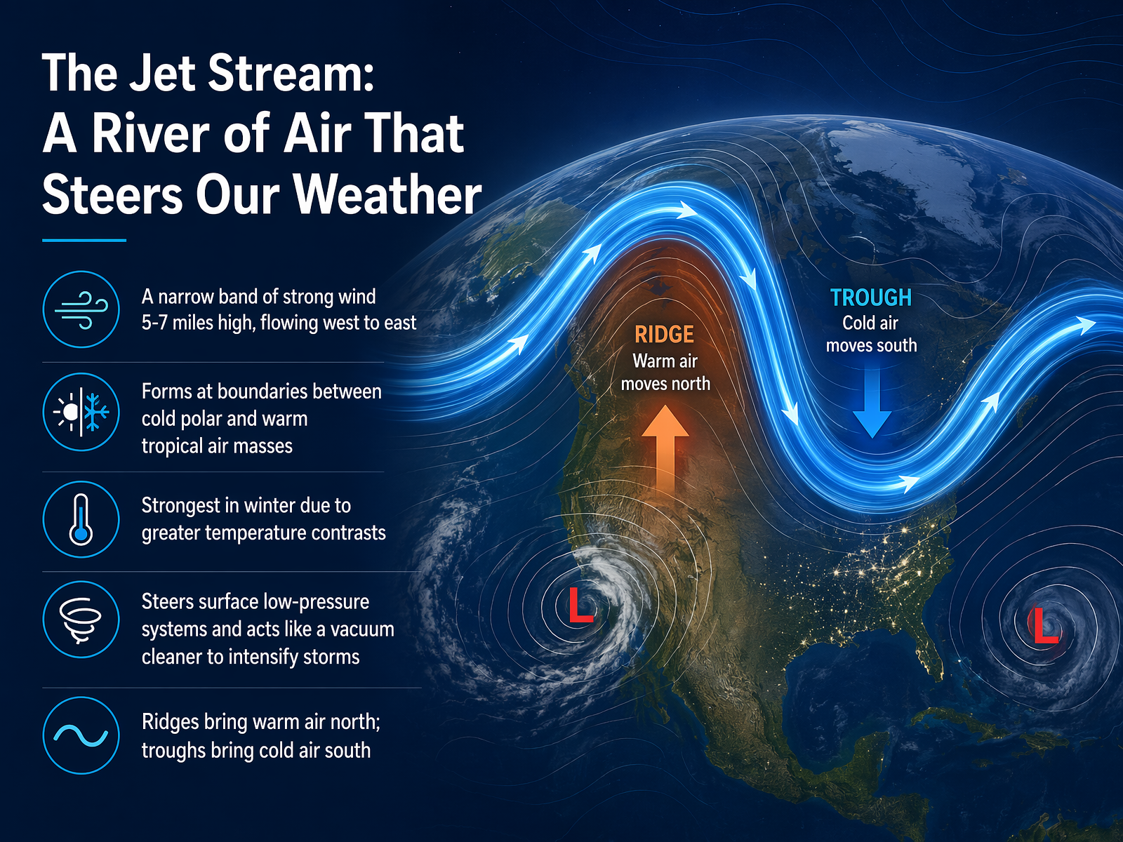
 - 07The Jet Stream: A River of Air That Steers Our WeatherNow, imagine a river of air racing high above us, around five to seven miles up. That's the jet stream. It's a narrow band of incredibly strong wind, flowing from west to east, and it forms right at the boundary where cold polar air meets warm tropical air. Think of it as a high-altitude steerer for our daily weather. Because this temperature contrast is biggest in winter, the jet stream is at its strongest then, really powering up our storms. It doesn't just steer low-pressure systems; it acts almost like a giant vacuum cleaner, sucking air out of the top to make those storms even more intense. And here's a simple way to picture its movement: when the jet stream bulges north in a ridge, it pulls warm air up with it. When it dips south in a trough, it sends cold air plunging down. These waves in the sky are a big reason your local forecast changes. Up next, let's see how these forces combine to create a perfectly designed storm: the mid-latitude cyclone.
 weather.metoffice.gov.ukmetoffice.gov.ukclimate.gov+22 min
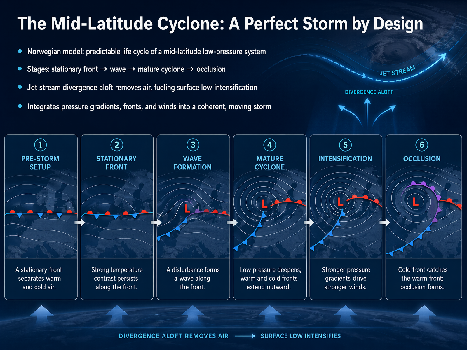
 - 08The Mid-Latitude Cyclone: A Perfect Storm by DesignNow let's pull it all together into what's called a mid-latitude cyclone. Think of it as a perfect storm by design, following a surprisingly predictable life cycle. Meteorologists call this the Norwegian model, and it starts with something simple: a stationary front, a boundary where cold air sits to the north and warm air to the south, both flowing in opposite directions. This creates a gentle spin, like a pen rolling between your hands. A kink, or wave, forms along that front, and a center of low pressure is born. As the wave intensifies, the cold front pushes south and the warm front pushes north, creating a distinct warm sector between them. The storm matures, and the faster cold front catches up to the warm front, forming an occluded front. That's when the storm is usually at its most intense. But what really fuels this whole process from above? Divergence in the jet stream. As the jet stream races overhead, it acts like a vacuum cleaner, removing air from the top of the storm. This allows the surface pressure to drop even further, making the cyclone spin faster and grow stronger. It's a beautiful integration of pressure gradients, fronts, and high-altitude winds all working together in one moving system. Next, we'll zoom in closer to home and explore how these principles create the local winds you feel every day, like sea breezes and mountain flows, right in your own backyard.
 weather.metoffice.gov.ukmetoffice.gov.ukclimate.gov+22 min
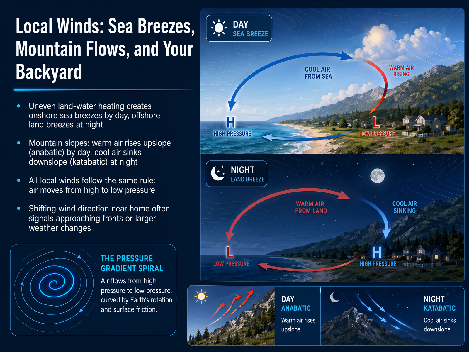
 - 09Local Winds: Sea Breezes, Mountain Flows, and Your BackyardWind isn’t just something that happens far away. It’s happening right in your own backyard, shaped by the land around you. Let’s look at how that works. During the day, the sun heats the ground faster than the water. The warm air over the land rises, creating a small area of low pressure. Cooler, higher-pressure air over the water rushes in to fill the gap, giving you that refreshing onshore sea breeze. At night, the land cools down quickly, but the water holds its heat. Now the pressure pattern flips. The higher pressure is over the cooler land, and the wind shifts offshore, becoming a land breeze. Mountains create their own daily rhythm too. Sunlight warms the slopes, and the air right next to them heats up and rises. This is called an upslope or anabatic wind. After sunset, the mountain surface cools rapidly, chilling the air. That cooler, denser air then sinks and slides down into the valleys as a katabatic wind. All of these local winds, whether it’s a sea breeze or a mountain flow, follow the same simple rule: air always moves from areas of high pressure toward areas of low pressure. It’s that pressure difference that gets the air moving. And here’s something to watch for at home. A sudden, persistent shift in your local wind direction, like a breeze that was coming from the south and now swings around to the northwest, often signals that a larger weather system, like a cold front or a new low-pressure system, is approaching. Your backyard wind is a natural signal of bigger changes coming. Now, let’s step back and see how all these local and regional forces connect to the planet’s master wind plan. Next, we’re linking it all together in “Linking It All Together: From Global Flow to Your Forecast.”
 nesdis.noaa.govgeo.libretexts.orgniwa.co.nz+22 min
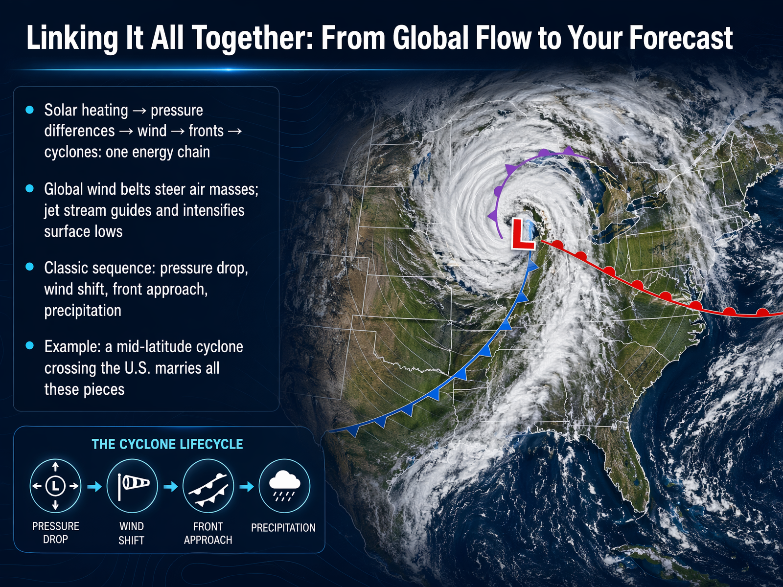
 - 10Linking It All Together: From Global Flow to Your ForecastNow let’s tie all the pieces together. You’ve got solar heating creating pressure differences, which drive wind, which shapes fronts, and eventually spins up a full mid-latitude cyclone. It’s one long energy chain. The global wind belts steer huge air masses, and the jet stream acts like a high‑speed highway above, guiding surface lows and sometimes making them more intense. When a classic storm approaches, you feel a pressure drop, then the wind shifts, you see clouds thicken, and precipitation arrives. Take a mid‑latitude cyclone crossing the United States—it starts as a small wave on a front, deepens as the jet stream pulls air upward, and brings a sharp change from warm southerly winds to gusty, cooler air behind the cold front. That one storm marries heat, pressure, wind, and moisture into a pattern you can actually watch on a weather map. Coming up next, we’ll decode those maps, looking at symbols, station models, and isobars so you can read a forecast like a pro.
 weather.metoffice.gov.ukmetoffice.gov.ukclimate.gov+21 min
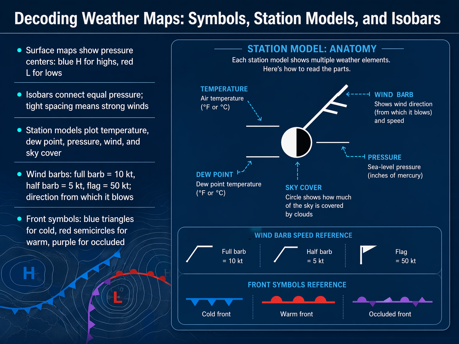
 - 11Decoding Weather Maps: Symbols, Station Models, and IsobarsNow, a weather map can look like a puzzle at first, but once you know the code, it tells you an amazing story. Let’s decode it together. First, look for the big blue H and the red L. The H is a high-pressure center, where air sinks and skies usually stay clear. The L is a low-pressure center, where air rises and can spin up clouds and storms. Around these letters, you’ll see thin lines called isobars. They connect points of equal air pressure. When those lines are packed tightly together, it means the pressure changes quickly over a short distance, and that’s what drives strong winds. If they’re spread out, expect a much calmer day. You’ll also see tiny weather reports plotted right on the map at each city. These are station models. They pack a lot of information into a small space, showing you the temperature, the dew point, the air pressure, wind, and cloud cover. The wind is shown with a wind barb. A full barb equals ten knots, a half barb is five, and a little flag means fifty. The barb points in the direction the wind is coming from. Then, there are the fronts. A blue line with triangles is a cold front, a red line with semicircles is a warm front, and a purple line with both is an occluded front, where a cold front has caught up to a warm one. These symbols are your guide to seeing how the atmosphere is moving, right now. This map work sets us up perfectly to talk about fair-weather patterns, specifically highs, ridges, and those clear blue skies.
 noaa.govscied.ucar.eduweather.metoffice.gov.uk+22 min
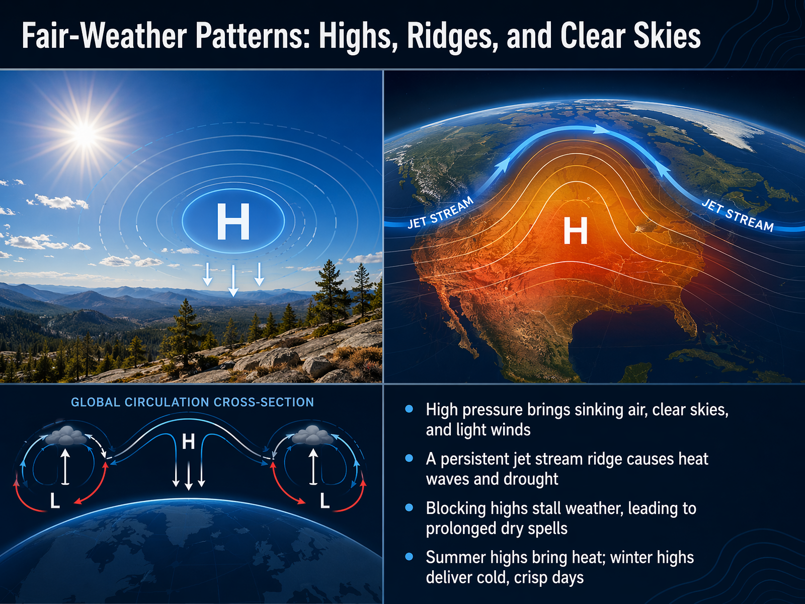
 - 12Fair-Weather Patterns: Highs, Ridges, and Clear SkiesNow, let's turn to the kind of weather everyone loves to see in the forecast. We're talking about fair-weather patterns, driven by high pressure. Think of a high-pressure system as a mountain of dense, heavy air. This air sinks, and as it sinks, it warms and dries out. The result? Those beautiful clear blue skies and light, gentle winds. It's the atmosphere putting a lid on cloud formation. But when a ridge in the jet stream, that high-altitude river of wind, gets stuck in place, it can park a high-pressure system over an area for days or even weeks. Meteorologists call this a blocking high, and it's a classic setup for serious heat waves and long, dry spells. The feeling of a high also depends on the season. In summer, that sinking sun-baked air delivers a scorching heat wave. But in winter, that same clear-sky pattern often brings us cold, crisp, and brilliantly sunny days. So, a fair-weather pattern is a double-edged sword, bringing a welcome sunny day or a persistent drought. Next, we'll flip the script and explore the stormy side of the coin with lows, troughs, and active weather.
 weather.metoffice.gov.ukmetoffice.gov.ukclimate.gov+22 min
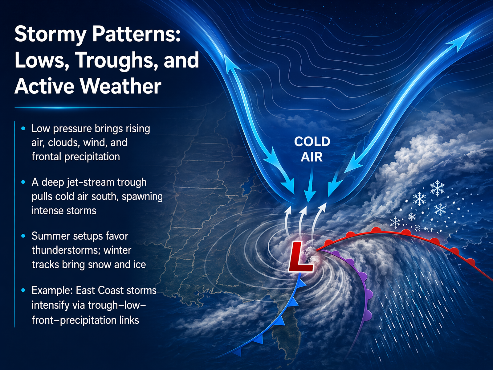
 - 13Stormy Patterns: Lows, Troughs, and Active WeatherNow let’s look at what happens when the atmosphere really gets active. Low-pressure systems are the main drivers of stormy weather. Inside a low, air rises and cools, water vapor condenses, and you get clouds, wind, and precipitation. When a deep trough forms in the jet stream, it pulls cold air far to the south and helps spin up intense storms. In summer, these setups often trigger clusters of thunderstorms. In winter, the same pattern can deliver bands of snow and ice. A classic example is a big East Coast storm. An upper-level trough deepens, a surface low intensifies, fronts sharpen, and heavy precipitation breaks out. It’s a connected chain, and once you see the pieces, you can almost feel the storm coming. Next, we’ll explore how these patterns shift with the seasons in “Seasonal Shifts: Why Your Weather Changes Through the Year.”
 weather.metoffice.gov.ukmetoffice.gov.ukclimate.gov+21 min
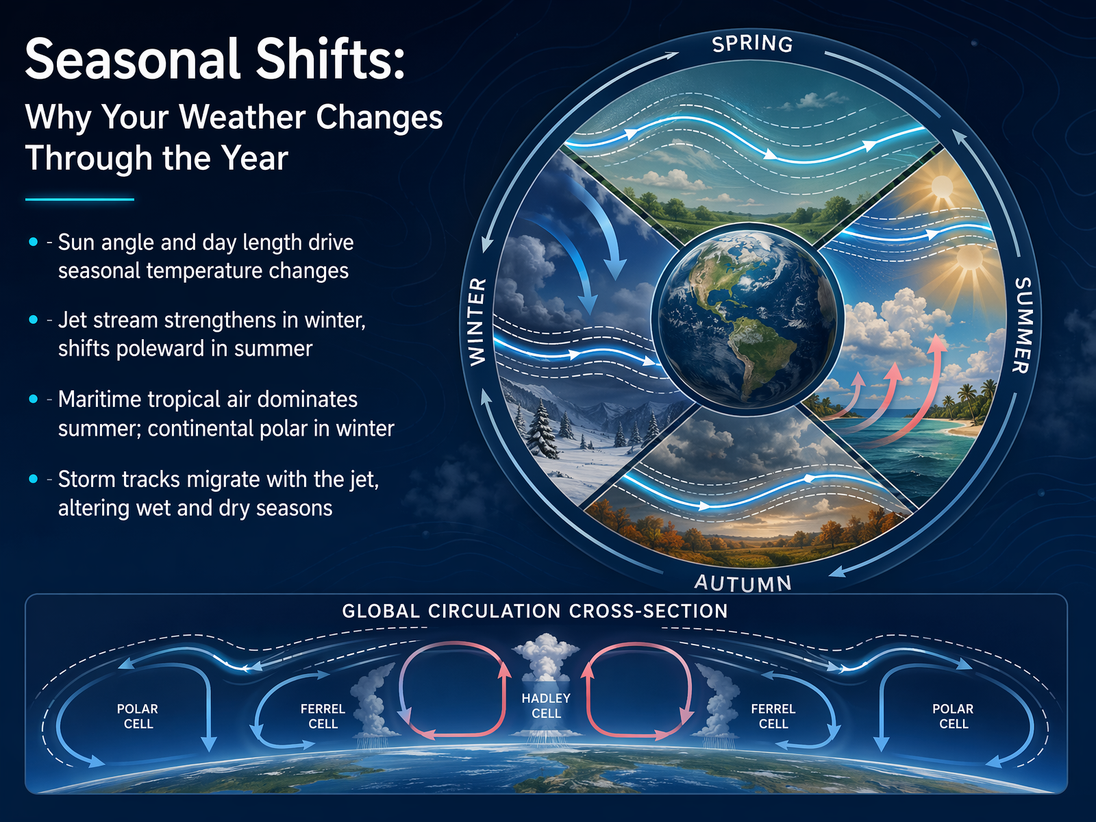
 - 14Seasonal Shifts: Why Your Weather Changes Through the YearNow, let's pull everything together and look at the big seasonal shifts. Why does your weather actually change through the year? It starts with the sun. In summer, the sun is higher in the sky and the days are longer, giving the ground more time to heat up. That's the fundamental engine. But our guiding force, the jet stream, also changes with the seasons. In winter, the temperature contrast between the cold pole and warm equator is huge, so the jet stream strengthens and often parks itself right over us, acting like a storm track for wet and windy weather. In summer, that contrast weakens, and the jet stream shifts north, letting calmer, high-pressure systems take over. This seasonal migration also changes the air masses we feel. In summer, we're often under maritime tropical air—think warm and humid. In winter, continental polar air dominates, bringing that crisp, cold, and dry chill. So, the changing sun angle, a shifting jet stream, and migrating air masses all work together to create the rhythm of our seasons. Next, let's step into your own backyard with 'Your Daily Weather Toolkit: Observations and Simple Forecasting'.
 weather.metoffice.gov.ukmetoffice.gov.ukclimate.gov+22 min
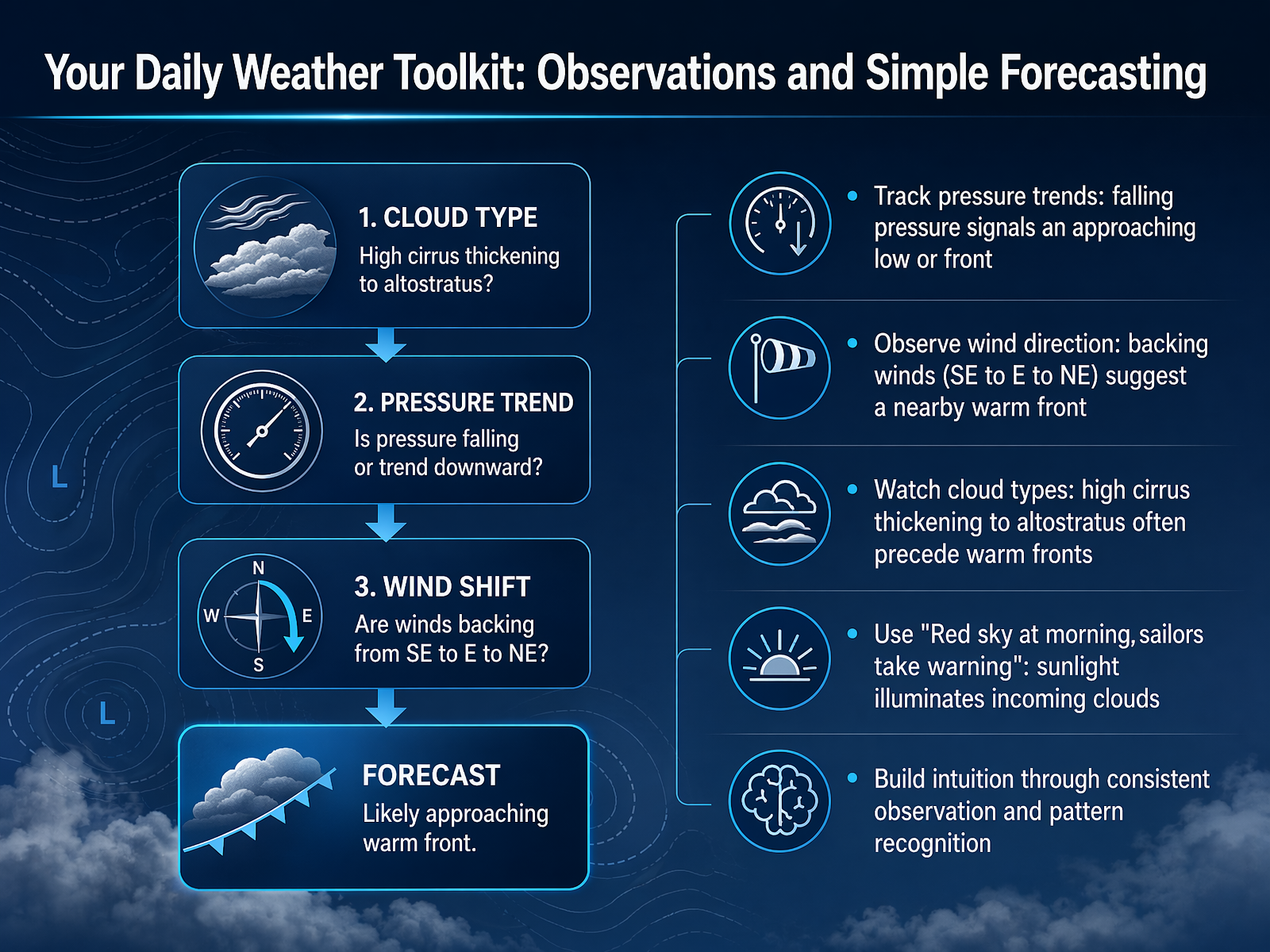
 - 15Your Daily Weather Toolkit: Observations and Simple ForecastingSo, how do you turn all this into your own daily forecast? It's really about building a simple observation toolkit. You don't need fancy equipment; you just need to track a few things. First, watch your barometric pressure. If it's steadily falling, that's a big clue that a low-pressure system, or a front, is heading your way, and the weather will likely change soon. Next, feel the wind direction. If you notice the wind shifting from southeast to east, and then to northeast—what we call 'backing'—that often signals a nearby warm front is approaching. And look up at the clouds. See those wispy, high cirrus clouds that start to thicken into a gray sheet of altostratus? That's a classic sign that a warm front and steady rain are probably a day or so away. You can even use old sayings, like 'Red sky at morning, sailors take warning.' It's based on science: the sun rising in the east illuminates the base of incoming clouds from an approaching storm system. The key is consistent observation. The more you watch and connect these patterns, the stronger your intuition becomes. It's like learning the sky's own language.
 scied.ucar.eduweather.metoffice.gov.ukokfirst.mesonet.org+22 min
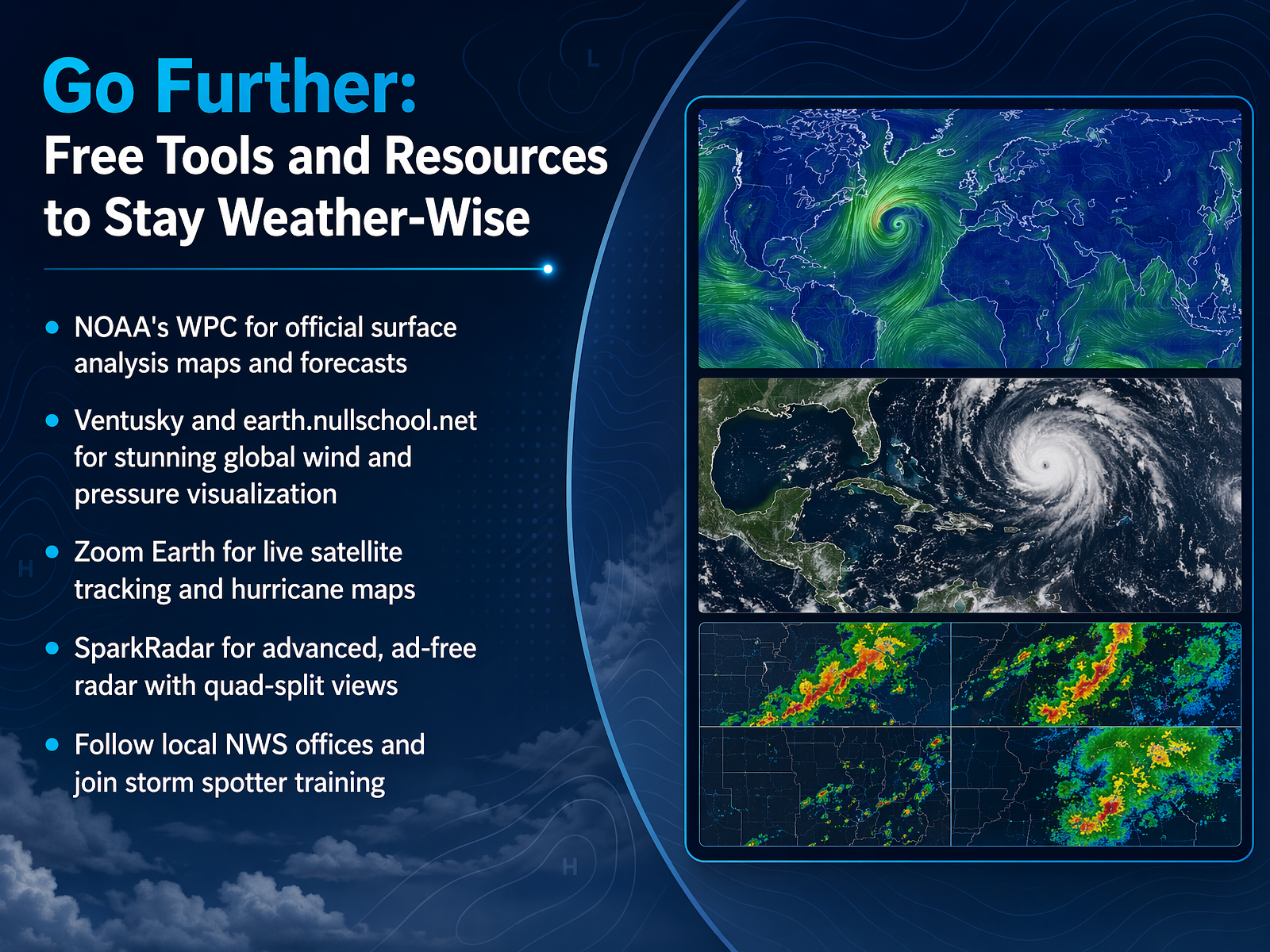
 - 16Go Further: Free Tools and Resources to Stay Weather-WiseWe've covered a lot of ground, and now you might be wondering, where can I explore all of this on my own? I want to leave you with a few fantastic, mostly free tools that let you peek behind the curtain and become your own weather detective. First, for the official picture, the N O A A Weather Prediction Center publishes surface analysis maps. That's where you'll see those highs, lows, and fronts drawn by human meteorologists, just like we've been talking about. For a stunning, interactive view of the planet, check out earth dot nullschool dot net. You can spin the globe and watch the jet stream snake across the ocean, or see wind spiraling into a giant low-pressure system. It really makes the connection between pressure and wind click. If you want to track a hurricane with live satellite imagery, Zoom Earth is a great tool, and for a clean, ad-free radar experience, try SparkRadar. Finally, your local National Weather Service office is a treasure trove. They offer free storm spotter training classes, which are a fantastic way to learn how severe weather works from the ground. So, step outside, look up, and use these tools to connect the dots. The sky is telling a story, and now you know how to read it. Thanks for learning with me, and happy weather watching.
 noaa.gov2 min
Take the deck with you
Download this course as a file — free, no sign-up needed.
- PDF handoutEvery slide page, ready to print or share.17 pages · 5.6 MBDownload
- Narrated PowerPointThe deck that presents itself — every slide carries the digital human's narration video.17 pages · 19.1 MBDownload
- PowerPoint slidesThe full deck as a .pptx — open it in PowerPoint, Keynote, or Google Slides.17 pages · 5.6 MBDownload
Free to use in your own training — please keep the PersonWise credit page at the end.
Have your own deck? Turn it into a course
Sources consulted
Web sources consulted while building this course.
- Global Wind Belts — flexbooks.ck12.org
- 10.20: Global Wind Belts - K12 LibreTexts — k12.libretexts.org
- Climate Science Investigations South Florida - Global Wind Patterns — ces.fau.edu
- 16.7: Global Atmospheric Circulations - Geosciences LibreTexts — geo.libretexts.org
- Global Wind Explained — serc.carleton.edu
- Why Does Wind Blow? | NESDIS | National Environmental Satellite, Data, and Information Service — nesdis.noaa.gov
- 1.5: Lab 5 - Atmospheric Pressure and Wind - Geosciences LibreTexts — geo.libretexts.org
- Lesson 2: Wind | Earth Sciences New Zealand | NIWA — niwa.co.nz
- Why does the wind blow? — lsop.colostate.edu
- Why the Wind Blows | Center for Science Education — scied.ucar.edu
- Weather Fronts - UCAR Center for Science Education — scied.ucar.edu
- Weather fronts - Met Office — weather.metoffice.gov.uk
- Weather Fronts — okfirst.mesonet.org
- 11.3: Surface Fronts - Geosciences LibreTexts — geo.libretexts.org
- How to read Surface Weather Maps | National Oceanic and Atmospheric Administration — noaa.gov
- What is the jet stream? - Met Office — weather.metoffice.gov.uk
- What is the jet stream and how does it affect our weather? — metoffice.gov.uk
- What is the jet stream? | NOAA Climate.gov — climate.gov
- What Is the Jet Stream? | NESDIS — nesdis.noaa.gov
- What Is The Jet Stream? Your Meteorology 101 Guide. | Weather.com — weather.com